Silk Road
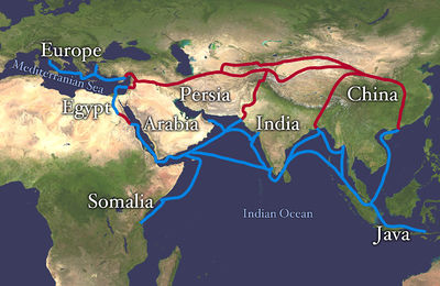
The Silk Road (German: Seidenstraße) (or Silk Routes) is an extensive interconnected network of trade routes across the Asian continent connecting East, South, and Western Asia with the Mediterranean world, as well as North and Northeast Africa and Europe. The Silk Road gets its name from the lucrative Chinese silk trade, a major reason for the connection of trade routes into an extensive trans-continental network.[1][2][3] The term "Seidenstraße" (literally "Silk Road") was coined retrospectively by the German geographer Ferdinand von Richthofen in 1877 and has since found its way into general usage. In recent years, both the maritime and overland Silk Routes are again being used, often closely following the ancient routes.
Contents |
Overview
The Silk Routes (collectively known as the 'Silk Road') were important paths for cultural, commercial and technological exchange between traders, merchants, pilgrims, missionaries, soldiers, nomads and urban dwellers from Ancient China, Ancient India, Ancient Tibet, Persia and Mediterranean countries for almost 3,000 years.[4] It gets its name from the lucrative Chinese silk trade, which began during the Han Dynasty (206 BCE–220 CE).
Extending 4,000 miles, the routes enabled people to transport goods, especially luxuries such as slaves, silk, satin and other fine fabrics, musk, other perfumes, spices, medicines, jewels, glassware and even rhubarb, as well as serving as a conduit for the spread of knowledge, ideas, cultures and diseases[5] between different parts of the world (Ancient China, Ancient India[Indus valley, now Pakistan], Asia Minor and the Mediterranean). Trade on the Silk Road was a significant factor in the development of the great civilizations of China, India, Egypt, Persia, Arabia and Rome, and in several respects helped lay the foundations for the modern world. Although the term the Silk Road implies a continuous journey, very few who traveled the route traversed it from end to end. For the most part, goods were transported by a series of agents on varying routes and were traded in the bustling mercantile markets of the oasis towns.[5]

The central Asian sections of the trade routes were expanded around 114 BCE by the Han dynasty,[6] largely through the missions and explorations of Zhang Qian,[7] but earlier trade routes across the continents already existed. In the late Middle Ages, transcontinental trade over the land routes of the Silk Road declined as sea trade increased.[8] Though silk was certainly the major trade item from China, many other products were traded, and various technologies, religions and philosophies as well as the bubonic plague (the so-called 'Black Death') also traveled along the Silk Routes. India played a vital role in the trade, being virtually by the center of the route as well as having unique products such as spices, precious stones, and hand-crafted goods.
Etymology
The first person who used the term "Seidenstraße" (literally "Silk Road") was the German geographer Ferdinand von Richthofen in 1877. The Silk Road gets its name from the lucrative Chinese silk trade, a major reason for the connection of trade routes into an extensive trans-continental network.[1][2][9]
Routes taken
Overland routes
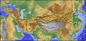
As it extends westwards from the ancient commercial centers of China, the overland, intercontinental Silk Road divides into the northern and southern routes bypassing the Taklamakan Desert and Lop Nur.
The northern route started at Chang'an (now called Xi'an), the capital of the ancient Chinese Kingdom, which, in the Later Han, was moved further east to Luoyang. The route was defined about the 1st Century BCE as Han Wudi put an end to harassment by nomadic tribes.
The route travels northwest through the Chinese province of Gansu from Shaanxi Province, and splits into three further routes, two of them following the mountain ranges to the north and south of the Taklimakan Desert to rejoin at Kashgar; and the other going north of the Tian Shan mountains through Turpan, Talgar and Almaty (in what is now southeast Kazakhstan). The routes split west of Kashgar with one branch heading down the Alai Valley towards Termez and Balkh, while the other traveled through Kokand in the Fergana Valley, and then west across the Karakum Desert towards Merv, joining the southern route briefly.
One of the branch routes turned northwest to the north of the Aral and Caspian seas then and on to the Black Sea. Yet another route started at Xi'an, passed through the Western corridor beyond the Yellow Rivers, Xinjiang, Fergana (in present-day eastern Uzbekistan), Persia and Iraq before joining the western boundary of the Roman Empire. A route for caravans, the northern Silk Road brought to China many goods such as "dates, saffron powder and pistachio nuts from Persia; frankincense, aloes and myrrh from Somalia; sandalwood from India; glass bottles from Egypt, and other expensive and desirable goods from other parts of the world." In exchange, the caravans sent back bolts of silk brocade, lacquer ware and porcelain.[10]
The southern route is mainly a single route running from China, through Karakoram. Here it is nowadays the international paved road connecting Pakistan and China as the Karakoram Highway. It then continues to Turkestan–Khorasan region, Mesopotamia, and into Anatolia, with southward spurs enabling the journey to be completed by sea from various points. It starts out southwards in China. Crossing the high mountains, then it passes through northern Pakistan, over the Hindu Kush mountains, and into Afghanistan, rejoining the northern route briefly near Merv. From there it follows a nearly straight line west through mountainous northern Iran and the northern tip of the Syrian Desert to the Levant, where Mediterranean trading ships plied regular routes to Italy, and land routes went either north through Anatolia or south to North Africa. Another branch road traveled from Herat through Susa to Charax Spasinu at the head of the Persian Gulf and across to Petra and on to Alexandria and other eastern Mediterranean ports from where ships carried the cargoes to Rome.
| Part of a series on Trade routes |
|---|
| Amber Road · Hærvejen . Incense Route |
| Kamboja-Dvaravati Route . King's Highway |
| Roman-India routes . Royal Road |
| Silk Road · Spice Route . Tea route |
| Varangians to the Greeks · Via Maris |
| Triangular trade .Volga trade route |
| Trans-Saharan trade . Salt Route |
| Hanseatic League . Grand Trunk Road |
Maritime routes
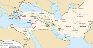
Going back nearly 2000 years, during China's Eastern Han Dynasty, a sea route, although not part of the formal Silk Route, led from the mouth of the Red River near modern Hanoi, through the Malacca Straits to Southeast Asia, Sri Lanka and India, and then on to the Persian Gulf and the Red Sea kingdom of Axum and eventual Roman ports. From ports on the Red Sea goods, including silks, were transported overland to the Nile and then to Alexandria from where they were shipped to Rome, Constantinople and other Mediterranean ports.[11]
Another branch of these sea routes led down the East African coast, called "Azania" by the Greeks and Romans in the 1st century CE, as described in the Periplus of the Erythraean Sea (and, very probably, 澤散 Zesan in the 3rd century by the Chinese),[12] at least as far as the port known to the Romans as "Rhapta," which was probably located in the delta of the Rufiji River in modern Tanzania.[13]
The Silk Road extends from Guangzhou, located in southern China, to present day Brunei, Myanmar (Burma) Thailand, Malacca, Ceylon, India, Pakistan, the Philippines, Iran and Iraq. In Europe it extends from Israel, Lebanon (Collectively, the Levant), Egypt, and Italy (historically, Venice) in the Mediterranean Sea to other European ports or caravan routes such as the great Hanseatic League fairs via the Spanish road and other Alpine routes. This water route in some sources is called the Indian Ocean Maritime System.
Background
Cross-continental journeys
As the domestication of pack animals and the development of shipping technology both increased the capacity for prehistoric peoples to carry heavier loads over greater distances, cultural exchanges and trade developed rapidly.
In addition, grassland provides fertile grazing, water, and easy passage for caravans. The vast grassland steppes of Asia enable merchants to travel immense distances, from the shores of the Pacific to Africa and deep into Europe, without trespassing on agricultural lands and arousing hostility.
Prehistoric transport and trade
Epipalaeolithic Natufians carried parthenocarpic figs from Africa to the southwestern corner of the Fertile Crescent, circa 10,000 BC.[14] Later migrations out of the Fertile Crescent would carry early agricultural practices to neighboring regions — westward to Europe and North Africa, northward to Crimea, and eastward to Mongolia.[15][16][17][18][19][20][21][22][23][24][25][26]
The ancient peoples of the Sahara imported domesticated animals from Asia between 6000 and 4000 BCE. In Nabta Playa by the end of the 7th millennium BCE, prehistoric Egyptians had imported goats and sheep from Southwest Asia.[27]
Foreign artifacts dating to the 5th millennium BCE in the Badarian culture in Egypt indicate contact with distant Syria. In predynastic Egypt, by the beginning of the 4th millennium BCE, ancient Egyptians in Maadi were importing pottery[28] as well as construction ideas from Canaan.
By the 4th millennium BCE shipping was well established, and the donkey and possibly the dromedary had been domesticated. Domestication of the Bactrian camel and use of the horse for transport then followed. Charcoal samples found in the tombs of Nekhen, which were dated to the Naqada I and II periods, have been identified as cedar from Lebanon.[29] Predynastic Egyptians of the Naqada I period also imported obsidian from Ethiopia, used to shape blades and other objects from flakes.[30] The Naqadans traded with Nubia to the south, the oases of the western desert to the west, and the cultures of the eastern Mediterranean to the east.[31]
Pottery and other artifacts from the Levant that date to the Naqadan era have been found in ancient Egypt.[32] Egyptian artifacts dating to this era have been found in Canaan[33] and other regions of the Near East, including Tell Brak[34] and Uruk and Susa[35] in Mesopotamia.
By the second half of the 4th millennium BCE, the gemstone lapis lazuli was being traded from its only known source in the ancient world — Badakshan, in what is now northeastern Afghanistan — as far as Mesopotamia and Egypt. By the 3rd millennium BCE, the lapis lazuli trade was extended to Harappa, Lothal and Mohenjo-daro in the Indus Valley Civilization (Ancient India) of modern day Pakistan and northwestern India. The Indus Valley was also known as Meluhha, the earliest maritime trading partner of the Sumerians and Akkadians in Mesopotamia. The ancient harbor constructed in Lothal, India, around 2400 BCE is the oldest seafaring harbour known.[36]
Trans-Saharan trade
Main article: Trans-Saharan trade.
The overland route through the Wadi Hammamat from the Nile to the Red Sea was known as early as predynastic times;[37] drawings depicting Egyptian reed boats have been found along the path dating to 4000 BCE.[38] Ancient cities dating to the First Dynasty of Egypt arose along both its Nile and Red Sea junctions,[37] testifying to the route's ancient popularity. It became a major route from Thebes to the Red Sea port of Elim, where travelers then moved on to either Asia, Arabia or the Horn of Africa.[37] Records exist documenting knowledge of the route among Senusret I, Seti, Ramesses IV and also, later, the Roman Empire, especially for mining.[39]
The Darb el-Arbain trade route, passing through Kharga in the south and Asyut in the north, was used from as early as the Old Kingdom of Egypt for the transport and trade of gold, ivory, spices, wheat, animals and plants.[40] Later, Ancient Romans would protect the route by lining it with varied forts and small outposts, some guarding large settlements complete with cultivation.[41] Described by Herodotus as a road "traversed ... in forty days," it became by his time an important land route facilitating trade between Nubia and Egypt.[42] Its maximum extent was northward from Kobbei, 25 miles north of al-Fashir, passing through the desert, through Bir Natrum and Wadi Howar, and ending in Egypt.[43]
Egyptian maritime trade
Shipbuilding was known to the Ancient Egyptians as early as 3000 BCE,[44][45] and perhaps earlier.[45] Ancient Egyptians knew how to assemble planks of wood into a ship hull, with woven straps used to lash the planks together,[44] and reeds or grass stuffed between the planks helped to seal the seams.[44] The Archaeological Institute of America reports[44] that the earliest dated ship — 75 feet long, dating to 3000 BCE[45] — may have possibly belonged to Pharaoh Aha.[45]
An Egyptian colony stationed in southern Canaan dates to slightly before the First Dynasty.[46] Narmer had Egyptian pottery produced in Canaan — with his name stamped on vessels — and exported back to Egypt,[47] from regions such as Arad, En Besor, Rafiah, and Tel Erani.[47] In 1994 excavators discovered an incised ceramic shard with the serekh sign of Narmer, dating to circa 3000 BCE. Mineralogical studies reveal the shard to be a fragment of a wine jar exported from the Nile valley to Palestine.
The Palermo stone mentions King Sneferu of the 4th Dynasty sending ship to import high-quality cedar from Lebanon. In one scene in the pyramid of Pharaoh Sahure of the Fifth Dynasty, Egyptians are returning with huge cedar trees. Sahure's name is found stamped on a thin piece of gold on a Lebanon chair, and 5th dynasty cartouches were found in Lebanon stone vessels. Other scenes in his temple depict Syrian bears. The Palermo stone also mentions expeditions to Sinai as well as to the diorite quarries northwest of Abu Simbel.
The oldest known expedition to the Land of Punt was organized by Sahure, which apparently yielded a quantity of myrrh, along with malachite and electrum. Around 1950 BCE, in the reign of Mentuhotep III, an officer named Hennu made one or more voyages to Punt. In the 15th century BCE, Nehsi conducted a very famous expedition for Queen Hatshepsut to obtain myrrh; a report of that voyage survives on a relief in Hatshepsut's funerary temple at Deir el-Bahri. Several of her successors, including Thutmoses III, also organized expeditions to Punt.
Ancient canal construction
The legendary Sesostris (likely either Pharaoh Senusret II or Senusret III of the Twelfth dynasty of Egypt[48][49]) is said to have started work on an ancient "Suez" Canal joining the River Nile with the Red Sea. This ancient account is corroborated by Aristotle, Pliny the Elder, and Strabo.[50]
One of their kings tried to make a canal to it (for it would have been of no little advantage to them for the whole region to have become navigable; Sesostris is said to have been the first of the ancient kings to try), but he found that the sea was higher than the land. So he first, and Darius afterwards, stopped making the canal, lest the sea should mix with the river water and spoil it.[51]
165. Next comes the Tyro tribe and, on the Red Sea, the harbour of the Daneoi, from which Sesostris, king of Egypt, intended to carry a ship-canal to where the Nile flows into what is known as the Delta; this is a distance of over 60 miles. Later the Persian king Darius had the same idea, and yet again Ptolemy II, who made a trench 100 feet wide, 30 feet deep and about 35 miles long, as far as the Bitter Lakes.[52]
Remnants of an ancient west-east canal, running through the ancient Egyptian cities of Bubastis, Pi-Ramesses, and Pithom were discovered by Napoleon Bonaparte and his cadre of engineers and cartographers in 1799.[53][54][55][56][57] Other evidence seems to indicate the existence of an ancient canal around the 13th century BC, during the time of Ramesses II.[58][59][60][61][62] Later construction efforts continued during the reigns of Necho II, Darius I of Persia and Ptolemy II Philadelphus.
"Psammetichus left a son called Necos, who succeeded him upon the throne. This prince was the first to attempt the construction of the canal to the Red Sea — a work completed afterwards by Darius the Persian — the length of which is four days’ journey, and the width is such as to admit of two triremes being rowed along it abreast. The water is derived from the Nile, which the canal leaves a little above the city of Bubastis, near Patumus, the Arabian town, being continued thence until it joins the Red Sea." [63]
"This [the canal from the Nile to the Red Sea] was begun by Necho II [610 BCE - 595 BCE], and completed by Darius I, who set up stelae c. 490 [BCE], ... and later restored by Ptolemy II Philadelphus, Trajan and Hadrian, and Amr ibn el-'Asi, the Muslim conqueror of Egypt. Its length from Tell el-Maskhuta to Suez was about 85 km.[64]
Shipping over the Nile River and from Old Cairo and through Suez continued further through the efforts of either 'Amr ibn al-'As,[58] Omar the Great,[54] or Trajan.[54][58] The Abbasid Caliph al-Mansur is said to have ordered this ancient canal closed so as to prevent supplies from reaching Arabian detractors.[54][58]
Chinese and Central Asian contacts
From the 2nd millennium BCE nephrite jade was being traded from mines in the region of Yarkand and Khotan to China. Significantly, these mines were not very far from the lapis lazuli and spinel ("Balas Ruby") mines in Badakhshan and, although separated by the formidable Pamir Mountains, routes across them were, apparently, in use from very early times.
The Tarim mummies, mummies of non-Mongoloid, apparently Caucasoid, individuals, have been found in the Tarim Basin, in the area of Loulan located along the Silk Road 200 km East of Yingpan, dating to as early as 1600 BCE and suggesting very ancient contacts between East and West. It has been suggested that these mummified remains may have been of people related to the Tocharians whose Indo-European language remained in use in the Tarim Basin (in modern day Xinjiang Uyghur Autonomous Region of China) until the 8th century.
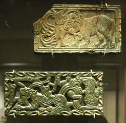
Following contacts of metropolitan China with nomadic western border territories in the 8th century BCE, gold was introduced from Central Asia, and Hotan Kashteshi Hotan jade carvers began to make imitation designs of the steppes, adopting the Scythian-style animal art of the steppes (descriptions of animals locked in combat). This style is particularly reflected in the rectangular belt plaques made of gold and bronze with alternate versions in jade and steatite.
The expansion of Scythian cultures stretching from the Hungarian plain and the Carpathians to the Chinese Kansu Corridor and linking Iran, and the Middle East with Northern India and the Punjab, undoubtedly played an important role in the development of the Silk Road. Scythians accompanied the Assyrian Esarhaddon on his invasion of Egypt, and their distinctive triangular arrowheads have been found as far south as Aswan. These nomadic peoples were dependent upon neighbouring settled populations for a number of important technologies, and in addition to raiding vulnerable settlements for these commodities, also encouraged long distance merchants as a source of income through the enforced payment of tariffs. Soghdian Scythian merchants played a vital role in later periods in the development of the Silk Road.
Persian Royal Road
By the time of Herodotus (c. 475 BCE), the Persian Royal Road ran some 2,857 km from the city of Susa on the Karun (250 km east of the Tigris) to the port of Smyrna (modern İzmir in Turkey) on the Aegean Sea.[65] It was maintained and protected by the Achaemenid Empire (c.500–330 BCE), and had postal stations and relays at regular intervals. By having fresh horses and riders ready at each relay, royal couriers could carry messages the entire distance in nine days, though normal travellers took about three months. This Royal Road linked into many other routes. Some of these, such as the routes to India and Central Asia, were also protected by the Achaemenids, encouraging regular contact between India, Mesopotamia and the Mediterranean. There are accounts in the biblical Book of Esther of dispatches being sent from Susa to provinces as far out as India and the Kingdom of Kush during the reign of Xerxes the Great (485–465 BCE).
History
Hellenistic era
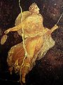
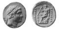 Coin depicting the Greco-Bactrian king Euthydemus (230–200 BCE) |
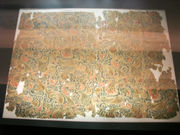
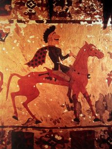
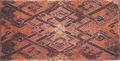
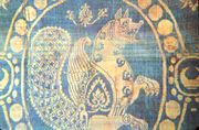
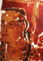 Probable Greek soldier in the Sampul tapestry, woollen wall hanging, 3rd–2nd century BCE, Sampul, Urumqi Xinjiang Museum. |
The first major step in opening the Silk Road between the East and the West came with the expansion of Alexander the Great's empire into Central Asia. In August 329 BCE, at the mouth of the Fergana Valley in Tajikistan he founded the city of Alexandria Eschate or "Alexandria The Furthest".[66] This later became a major staging point on the northern Silk Route.
In 323 BCE, Alexander the Great’s successors, the Ptolemaic dynasty, took control of Egypt. They actively promoted trade with Mesopotamia, India, and East Africa through their Red Sea ports and over land. This was assisted by a number of intermediaries, especially the Nabataeans and other Arabs.
The Greeks remained in Central Asia for the next three centuries, first through the administration of the Seleucid Empire, and then with the establishment of the Greco-Bactrian Kingdom in Bactria. They continued to expand eastward, especially during the reign of Euthydemus (230–200 BCE) who extended his control beyond Alexandria Eschate to Sogdiana. There are indications that he may have led expeditions as far as Kashgar in Chinese Turkestan, leading to the first known contacts between China and the West around 200 BCE. The Greek historian Strabo writes "they extended their empire even as far as the Seres (China) and the Phryni." [67]
Chinese exploration of Central Asia
 A late Zhou Dynasty or early Han Dynasty (c. 300–200 BCE) Chinese bronze mirror inlaid with glass and showing influence from Hellenistic civilization in Central Asia |
With the Mediterranean linked to the Fergana Valley, the next step was to open a route across the Tarim Basin and the Gansu Corridor to China Proper. This came around 130 BCE, with the embassies of the Han Dynasty to Central Asia, following the reports of the ambassador Zhang Qian[68] (who was originally sent to obtain an alliance with the Yuezhi against the Xiongnu). Some say that the Chinese Emperor Wu Di became interested in developing commercial relationships with the sophisticated urban civilizations of Ferghana, Bactria and Parthian Empire: "The Son of Heaven on hearing all this reasoned thus: Ferghana (Dayuan) and the possessions of Bactria (Ta-Hsia) and Parthian Empire (Anxi) are large countries, full of rare things, with a population living in fixed abodes and given to occupations somewhat identical with those of the Chinese people, but with weak armies, and placing great value on the rich produce of China" (Hou Hanshu, Later Han History). Others[69] say that Wu Di was mainly interested in fighting the Xiougnu and that major trade opened only when the Chinese pacified the Gansu Corridor.
The Chinese were also strongly attracted by the tall and powerful horses in the possession of the Dayuan (named "Heavenly horses"), which were of capital importance in fighting the nomadic Xiongnu. The Chinese subsequently sent numerous embassies, around ten every year, to these countries and as far as Seleucid Syria. "Thus more embassies were dispatched to Anxi [Parthia], Yancai [who later joined the Alans ], Lijian [Syria under the Seleucids], Tiaozhi [Chaldea], and Tianzhu [northwestern India]… As a rule, rather more than ten such missions went forward in the course of a year, and at the least five or six." (Hou Hanshu, Later Han History). The Roman historian Florus also describes the visit of numerous envoys, included Seres, to the first Roman Emperor Augustus, who reigned between 27 BCE and 14:
- "Even the rest of the nations of the world which were not subject to the imperial sway were sensible of its grandeur, and looked with reverence to the Roman people, the great conqueror of nations. Thus even Scythians and Sarmatians sent envoys to seek the friendship of Rome. Nay, the Seres came likewise, and the Indians who dwelt beneath the vertical sun, bringing presents of precious stones and pearls and elephants, but thinking all of less moment than the vastness of the journey which they had undertaken, and which they said had occupied four years. In truth it needed but to look at their complexion to see that they were people of another world than ours." ("Cathay and the way thither", Henry Yule).
The "Silk Road" came into being from the 1st century BCE, following these efforts by Uyghurs in East Turkestan to consolidate a road to the Western world and India, both through direct settlements in the area of the Tarim Basin and diplomatic relations with the countries of the Dayuan, Parthians and Bactrians further west.
A maritime "Silk Route" opened up between Chinese-controlled Giao Chỉ (centred in modern Vietnam [see map above], near Hanoi) probably by the 1st century. It extended, via ports on the coasts of India and Sri Lanka, all the way to Roman-controlled ports in Egypt and the Nabataean territories on the northeastern coast of the Red Sea.
Roman Empire
Soon after the Roman conquest of Egypt in 30 BCE, regular communications and trade between India, Southeast Asia, Sri Lanka, China, the Middle East, Africa and Europe blossomed on an unprecedented scale. The party of Maës Titianus became the travellers who penetrated farthest east along the Silk Road from the Mediterranean world, probably with the aim of regularizing contacts and reducing the role of middlemen, during one of the lulls in Rome's intermittent wars with Parthia, which repeatedly obstructed movement along the Silk Road. Land and maritime routes were closely linked, and novel products, technologies and ideas began to spread across the continents of Europe, Asia and Africa. Intercontinental trade and communication became regular, organized, and protected by the 'Great Powers.' Intense trade with the Roman Empire soon followed, confirmed by the Roman craze for Chinese silk (supplied through the Parthians), even though the Romans thought silk was obtained from trees. This belief was affirmed by Seneca the Younger in his Phaedra and by Virgil in his Georgics. Notably, Pliny the Elder knew better. Speaking of the bombyx or silk moth, he wrote in his Natural Histories "They weave webs, like spiders, that become a luxurious clothing material for women, called silk."[70]
The Senate issued, in vain, several edicts to prohibit the wearing of silk, on economic and moral grounds: the importation of Chinese silk caused a huge outflow of gold, and silk clothes were considered to be decadent and immoral:
- "I can see clothes of silk, if materials that do not hide the body, nor even one's decency, can be called clothes… Wretched flocks of maids labour so that the adulteress may be visible through her thin dress, so that her husband has no more acquaintance than any outsider or foreigner with his wife's body" (Seneca the Younger (c.3 BCE–65, Declamations Vol. I).
After losing at the battle of Carrhae in 53 BC, 10,000 Roman prisoners were sent by the Parthians to Margiana to help guard the eastern frontier of the Parthian Empire. It is possible that contingents of these men found their way into China.[71]
The Hou Hanshu records that the first Roman envoy arrived in China by this maritime route in 166, initiating a series of Roman embassies to China.
Medieval age
 1342 tomb of Katarina Vilioni, member of an Italian trading family in Yangzhou. |
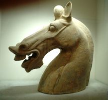
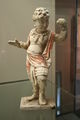 A Chinese Tang Dynasty (618–907) terracotta statuette of a foreign male dancer from the west, with traces of polychrome |
The main traders during Antiquity were the Indian and Bactrian traders, then from the 5th to the 8th century CE the Sogdian traders, then afterward the Arab and Persian traders. A.V.Dybo noted that "according to historians, the main driving force of the Great Silk Road were not just Sogdians, but the carriers of a mixed Sogdian-Türkic culture that often came from mixed families." [72]
The unification of Central Asia and Northern India within Kushan empire in the first to third centuries reinforced the role of the powerful merchants from Bactria and Taxila.[73] They fostered multi-cultural interaction as indicated by their 2nd century treasure hoards filled with products from the Greco-Roman world, China and India, such as in the archeological site of Begram.
The heyday of the Silk Road corresponds, on its west end, to the Byzantine Empire, Sassanid Empire Period to Il Khanate Period in the Nile-Oxus section and Three Kingdoms to Yuan Dynasty in the Sinitic zone in its east end. Trade between East and West also developed on the sea, between Alexandria in Egypt and Guangzhou in China, fostering across the Indian Ocean. The Silk Road represents an early phenomenon of political and cultural integration due to inter-regional trade. In its heyday, the Silk Road sustained an international culture that strung together groups as diverse as the Magyars, Armenians, and Chinese.
Under its strong integrating dynamics on the one hand and the impacts of change it transmitted on the other, tribal societies previously living in isolation along the Silk Road or pastoralists who were of barbarian cultural development were drawn to the riches and opportunities of the civilizations connected by the Silk Road, taking on the trades of marauders or mercenaries. Many barbarian tribes became skilled warriors able to conquer rich cities and fertile lands, and forge strong military empires.
The Sogdians dominated the East-West trade after the 4th century CE up to the 8th century CE, with Suyab and Talas ranking among their main centers in the north. They were the main caravan merchants of Central Asia. Their commercial interests were protected by the resurgent military power of the Göktürks, whose empire has been described as "the joint enterprise of the Ashina clan and the Soghdians".[73][74] Their trades with some interruptions continued in the 9th century within the framework of the Uighur Empire, which until 840 extended across northern Central Asia and obtained from China enormous deliveries of silk in exchange for horses. At this time caravans of Sogdians traveling to Upper Mongolia are mentioned in Chinese sources. They played an equally important religious and cultural role. Part of the data about eastern Asia provided by Muslim geographers of the 10th century actually goes back to Sogdian data of the period 750-840 and thus shows the survival of links between east and west. However, after the end of the Uighur Empire, Sogdian trade went through a crisis. What mainly issued from Muslim Central Asia was the trade of the Samanids, which resumed the northwestern road leading to the Khazars and the Urals and the northeastern one toward the nearby Turkic tribes.[73]
The Silk Road gave rise to the clusters of military states of nomadic origins in North China, invited the Nestorian, Manichaean, Buddhist, and later Islamic religions into Central Asia and China, created the influential Khazar Federation and at the end of its glory, brought about the largest continental empire ever: the Mongol Empire, with its political centers strung along the Silk Road (Beijing in North China, Karakorum in central Mongolia, Sarmakhand in Transoxiana, Tabriz in Northern Iran, Sarai and Astrakhan in lower Volga, Solkhat in Crimea, Kazan in Central Russia, Erzurum in eastern Anatolia), realizing the political unification of zones previously loosely and intermittently connected by material and cultural goods.
The Roman Empire, and its demand for sophisticated Asian products, crumbled in the West around the 5th century. In Central Asia, Islam expanded from the 7th century onward, bringing a stop to Chinese westward expansion at the Battle of Talas in 751. Further expansion of the Islamic Turks in Central Asia from the 10th century finished disrupting trade in that part of the world, and Buddhism almost disappeared. For much of the Middle Ages, the Islamic Caliphate (centred in the Near East) often had a monopoly over much of the trade conducted across the Old World (see Muslim age of discovery for more details).
Mongol age

The Mongol expansion throughout the Asian continent from around 1207 to 1360 helped bring political stability and re-establish the Silk Road (via Karakorum). It also brought an end to the Islamic Caliphate's monopoly over world trade. The Chinese Mongol diplomat Rabban Bar Sauma visited the courts of Europe in 1287-1288 and provided a detailed written report back to the Mongols. Around the same time, the Venetian explorer Marco Polo became one of the first Europeans to travel the Silk Road to China, and his tales, documented in The Travels of Marco Polo, opened Western eyes to some of the customs of the Far East. He was not the first to bring back stories, but he was one of the widest-read. He had been preceded by numerous Christian missionaries to the East, such as William of Rubruck, Benedykt Polak, Giovanni da Pian del Carpine, and Andrew of Longjumeau. Later envoys included Odoric of Pordenone, Giovanni de' Marignolli, John of Montecorvino, Niccolò de' Conti, or Ibn Battuta, a Moroccan Muslim traveller, who passed through the present-day Middle East and across the Silk Road from Tabriz, between 1325-1354.[75][76]
The 13th century also saw attempts at a Franco-Mongol alliance, with exchange of ambassadors and (failed) attempts at military collaboration in the Holy Land during the later Crusades, though eventually the Mongols in the Ilkhanate, after they had destroyed the Abbasid and Ayyubid dynasties, eventually themselves converted to Islam, and signed the 1323 Treaty of Aleppo with the surviving Muslim power, the Egyptian Mamluks.
Some research studies indicate that the Black Death, which devastated Europe in the late 1340s, may have reached from Central Asia (or China) to Europe along the trade routes of the Mongol Empire.[77]
Disintegration
The fragmentation of the Mongol Empire loosened the political, cultural and economic unity of the Silk Road. Turkmeni marching lords seized land around the western part of the Silk Road, belonging to the decaying Byzantine Empire. After the Mongol Empire, the great political powers along the Silk Road became economically and culturally separated. Accompanying the crystallization of regional states was the decline of nomad power, partly due to the devastation of the Black Death and partly due to the encroachment of sedentary civilizations equipped with gunpowder.
Gunpowder and early modernity in Europe led to the integration of territorial states and increasing mercantilism. Meanwhile on the Silk Road, gunpowder and early modernity had the opposite impact: the level of integration of the Mongol Empire could not be maintained, and trade declined (though partly due to an increase in European maritime exchanges).
The Silk Road stopped serving as a shipping route for silk around 1400.
Great explorers: Europe reaching for Asia
The disappearance of the Silk Road following the end of the Mongols was one of the main factors that stimulated the Europeans to reach the prosperous Chinese empire through another route, especially by sea. Tremendous profits were to be obtained for anyone who could achieve a direct trade connection with Asia. This was the main driving factor for the Portuguese explorations of the Indic Ocean, including the sea of China, resulting in the arrival in 1513 of the first European trading ship to the coasts of China, under Jorge Álvares and Rafael Perestrello, followed by the Fernão Pires de Andrade and Tomé Pires diplomatic and commercial mission of 1517, under the orders of Manuel I of Portugal, which opened formally relations between the Portuguese Empire and the Ming Dynasty during the reign of the Zhengde Emperor. The handover of Macau (Macao) to Portugal in 1557 by the Emperor of China (as a reward for services rendered against the pirates who infested the China Sea) resulted in the first permanent European maritime trade post between Europe and China, with other European powers following suit over the next centuries, which caused the eventual demise of the Silk Road landroute.
When he went West in 1492, Christopher Columbus reportedly wished to create yet another Silk Route to China. It was initially a great disappointment to have found a continent "in-between" before recognizing the potential of a "New World."
In 1594, Willem Barents left Amsterdam with two ships to search for the Northeast passage north of Siberia, on to eastern Asia. He reached the west coast of Novaya Zemlya and followed it northward, being finally forced to turn back when confronted with its northern extremity. By the end of the 17th century, the Russians re-established a land trade route between Europe and China under the name of the Great Siberian Road.
The desire to trade directly with China and India was also the main driving force behind the expansion of the Portuguese beyond Africa after 1480, followed by the Netherlands and Great Britain from the 17th century. While the Portuguese (and, subsequently, other Europeans) were entering China from its southern coast, by the sea route, the question arose as to whether it happens to be the same country as Cathay which Marco had reached by the overland route. By ca. 1600, the Jesuits stationed in China, led by Matteo Ricci, were pretty sure that it was, but others were not convinced yet. To check the situation on the ground, Bento de Góis, a Portuguese former soldier and explorer that had joined the Jesuits as a Lay Brother in Goa, India, travelled in 1603-1605 from India via Afghanistan and one of the routes of the traditional Silk Road (via Badakhshan, the Pamirs, Yarkand, Kucha, and Turpan to the Ming China's border as Suzhou, Gansu.[78]
Leibniz, echoing the prevailing perception in Europe until the Industrial Revolution, wrote in the 17th century that: Everything exquisite and admirable comes from the East Indies... Learned people have remarked that in the whole world there is no commerce comparable to that of China.
In the 18th century, Adam Smith declared that China had been one of the most prosperous nations in the world, but that it had remained stagnant for a long time and its wages always were low and the lower classes were particularly poor:[79]
- China has long been one of the richest, that is, one of the most fertile, best cultivated, most industrious, and most populous countries in the world. It seems, however, to have been long stationary. Marco Polo, who visited it more than five hundred years ago, describes its cultivation, industry, and populousness, almost in the same terms as travellers in the present time describe them. It had perhaps, even long before his time, acquired that full complement of riches which the nature of its laws and institutions permits it to acquire. (Adam Smith, The Wealth of Nations, 1776).
Cultural exchanges
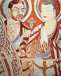
Notably, the Buddhist faith and the Greco-Buddhist culture started to travel eastward along the Silk Road, penetrating in China from around the 1st century BC.
The Silk Road transmission of Buddhism to China started in the 1st century CE with a semi-legendary account of an embassy sent to the West by the Chinese Emperor Ming (58 – 75 CE). Extensive contacts however started in the 2nd century CE, probably as a consequence of the expansion of the Kushan empire into the Chinese territory of the Tarim Basin, with the missionary efforts of a great number of Central Asian Buddhist monks to Chinese lands. The first missionaries and translators of Buddhists scriptures into Chinese were either Parthian, Kushan, Sogdian or Kuchean.
From the 4th century onward, Chinese pilgrims also started to travel on the Silk Road to India, the origin of Buddhism, by themselves in order to get improved access to the original scriptures, with Fa-hsien's pilgrimage to India (395–414), and later Xuan Zang (629–644). The legendary accounts of the holy priest Xuan Zang were described in a famous novel called Journey to the West, which envisaged trials of the journey with demons but with the help of various disciples.
The Silk Road transmission of Buddhism essentially ended around the 7th century with the rise of Islam in Central Asia.
Artistic transmission
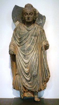
Many artistic influences transited along the Silk Road, especially through the Central Asia, where Hellenistic, Iranian, Indian and Chinese influence were able to intermix. In particular Greco-Buddhist art represent one of the most vivid examples of this interaction.
Buddhist deities
The image of the Buddha, originating during the 1st century in a small country in the north of India [now Nepal], was transmitted progressively through Central Asia and China until it reached Korea in the 4th century and Japan in the 6th century. However, it is clear that many Western iconographical details were also transmitted, such as the Hercules-inspired Nio guardian deities in front of Japanese Buddhist temples, and representations of the Buddha reminiscent of Greek art such as the Buddha in Kamakura.
Another Buddhist deity, Shukongoshin, is also an interesting case of transmission of the image of the famous Greek god Herakles to the far East along the Silk Road. Herakles was used in Greco-Buddhist art to represent Vajrapani, the protector of the Buddha, and his representation was then used in China, Korea, and Japan to depict the protector gods of Buddhist temples.
Wind god
The name of the west wind in Greek is Zephyr. Various other artistic influences from the Silk Road can be found in Asia, one of the most striking being that of the Greek wind god Boreas, transiting through Central Asia and China to become the Japanese Shinto wind god Fujin.[80]
New railway route
The last available link on the Silk Road was completed in 1990, when the railway systems of China and Kazakhstan connected in Alataw Pass (Alashan Kou). Currently (2008), the line is used by direct passenger service from Urumqi in China's Xinjiang to Almaty and Astana in Kazakhstan.[11].
Commemoration
Both Bishkek and Almaty now have a major east-west street named after the Silk Road (Kyrgyz: Жибек жолу, Jibek Jolu in Bishkek, and Kazakh: Жібек жолы, Jibek Joly in Almaty).
Museum
Artifacts from the history of the Silk Route are displayed in the Silk Route Museum in Jiuquan, China.
See also
- Cities along the Silk Road
- Dzungarian Gate
- Godavaya
- History of silk
- Hippie trail
- Incense Road
- Kamboja-Dvaravati Route
- Karakoram Highway
- Mount Imeon
- Serica
- Three hares
Notes
- ↑ 1.0 1.1 "Approaches Old and New to the Silk Roads" Vadime Eliseeff in: The Silk Roads: Highways of Culture and Commerce. Paris (1998) UNESCO, Reprint: Berghahn Books (2009), pp. 1-2. ISBN 92-3-103652-1; ISBN 1-57181-221-0; ISBN 1-57181-222-9 (pbk)
- ↑ 2.0 2.1 Waugh, Daniel. (2007). "Richthofen "Silk Roads": Toward the Archeology of a Concept." The Silk Road. Volume 5, Number 1, Summer 2007, p. 4.
- ↑ Hill, John E. 2003. "Annotated Translation of the Chapter on the Western Regions according to the Hou Hanshu." 2nd Draft Edition. Introduction [1]
- ↑ "ANCIENT SILK ROAD TRAVELERS [sic"]. www.silk-road.com. http://www.silk-road.com/artl/srtravelmain.shtml. Retrieved 2008-07-02.
- ↑ 5.0 5.1 Wood, Francis (2002). The Silk Road: Two Thousand Years in the Heart of Asia. Berkeley, CA: University of California Press. pp. 9, 13–23. ISBN 978-0-520-24340-8.
- ↑ Elisseeff, Vadime (2001). The Silk Roads: Highways of Culture and Commerce. UNESCO Publishing / Berghahn Books. pp. 332 pages. ISBN 978-92-3-103652-1.
- ↑ Boulnois, Luce (2005). Silk Road: Monks, Warriors & Merchants. Hong Kong: Odyssey Books. pp. 66. ISBN 962-217-721-2.
- ↑ Hogan, C. Michael. "The Megalithic Portal and Megalith Map: Silk Road, North China [Northern Silk Road, North Silk Road Ancient Trackway"]. www.megalithic.co.uk. http://www.megalithic.co.uk/article.php?sid=18006. Retrieved 2008-07-05.
- ↑ Hill, John E. 2003. "Annotated Translation of the Chapter on the Western Regions according to the Hou Hanshu." 2nd Draft Edition. Introduction [2]
- ↑ Ulric Killion, A Modern Chinese Journey to the West: Economic Globalization And Dualism, (Nova Science Publishers: 2006), p.66
- ↑ Casson, Lionel. 1989. The Periplus Maris Erythraei. Text with Introduction, Translation, and Commentary. Princeton University Press. ISBN 0-691-04060-5.
- ↑ [3]
- ↑ "The Egypto-Graeco-Romans and Panchea/Azania: sailing in the Erythraean Sea." Felix A. Chami. In: Society for Arabian Studies Monographs 2 Trade and Travel in the Red Sea Region. Proceedings of Red Sea Project I held in the British Museum October 2002, pp. 93-104. Edited by Paul Lunde and Alexandra Porter. ISBN 1841716227.
- ↑ Kislev ME, Hartmann A, Bar-Yosef O (2006) Early domesticated fig in the Jordan Valley. Nature 312:1372–1374.
- ↑ Chicki, L; Nichols, RA; Barbujani, G; Beaumont, MA. 2002. Y genetic data support the Neolithic demic diffusion model. Proc. Nat. Acad. Sci. 99(17): 11008-11013.
- ↑ Estimating the Impact of Prehistoric Admixture on the Genome of Europeans, Dupanloup et al., 2004
- ↑ Origin, Diffusion, and Differentiation of Y-Chromosome Haplogroups E and J: Inferences on the Neolithization of Europe and Later Migratory Events in the Mediterranean Area, 2004
- ↑ Paleolithic and Neolithic lineages in the European mitochondrial gene pool, Cavalli-Sforza 1997.
- ↑ Clines of nuclear DNA markers suggest a largely Neolithic ancestry of the European gene, Chikhi 1997.
- ↑ M. Zvelebil, in Hunters in Transition: Mesolithic Societies and the Transition to Farming, M. Zvelebil (editor), Cambridge University Press: Cambridge, UK (1986) pp. 5-15, 167–188.
- ↑ P. Bellwood, First Farmers: The Origins of Agricultural Societies, Blackwell: Malden, MA (2005).
- ↑ M. Dokládal, J. Brožek, Curr. Anthropol. 2 (1961) pp. 455–477.
- ↑ O. Bar-Yosef, Evol. Anthropol. 6 (1998) pp. 159–177.
- ↑ M. Zvelebil, Antiquity 63 (1989) pp. 379–383.
- ↑ C. Loring Brace, Noriko Seguchi, Conrad B. Quintyn, Sherry C. Fox, A. Russell Nelson, Sotiris K. Manolis, and Pan Qifeng, "The questionable contribution of the Neolithic and the Bronze Age to European craniofacial form," in Proceedings of the National Academy of Sciences of the USA (Jan. 3, 2006). Vol. 103, No. 1, pp. 242-247. [4] doi: 10.1073/pnas.0509801102
- ↑ F. X. Ricaut, M. Waelkens, "Cranial Discrete Traits in a Byzantine Population and Eastern Mediterranean Population Movements," in Human Biology, Wayne State University Press (Aug. 2008). Vol. 80, Issue 5, pp. 535-564. [5] doi: 10.3378/1534-6617-80.5.535
- ↑ Fred Wendorf and Romuald Schild, 2000. Late Neolithic megalithic structures at Nabta Playa (Sahara), southwestern Egypt.
- ↑ Maadi Culture
- ↑ Parsons, Marie. "Egypt: Hierakonpolis, A Feature Tour Egypt Story". www.touregypt.net. http://www.touregypt.net/featurestories/hierakonpolis.htm. Retrieved 2008-07-09.
- ↑ Barbara G. Aston, James A. Harrell, Ian Shaw (2000). Paul T. Nicholson and Ian Shaw editors. "Stone," in Ancient Egyptian Materials and Technology, Cambridge, 5-77, pp. 46-47. Also note: Barbara G. Aston (1994). "Ancient Egyptian Stone Vessels," Studien zur Archäologie und Geschichte Altägyptens 5, Heidelberg, pp. 23-26. (See on-line posts: [6] and [7].)
- ↑ Shaw, Ian (2002). The Oxford History of Ancient Egypt. Oxford, England: Oxford University Press. p. 61. ISBN 0-500-05074-0.
- ↑ Branislav Andelkovic, 1995. The Relations between Early Bronze Age I Canaanites and Upper Egyptians, Belgrade, p. 58, map 2. Branislav Andelkovic, 2002. Southern Canaan as an Egyptian Protodynastic Colony. Cahiers Caribéens d`Egyptologie 3-4: 75-92.
- ↑ Branislav Andelkovic, 1995, pp. 68-69, map 1; Branislav Andelkovic 2002.
- ↑ Places where cylinder seals similar to that from Naqada tomb 1863 have been found.
- ↑ Dominique Collon, 1987. First Impressions, Cylinder Seals in the Ancient Near East, London, pp. 13-14.
- ↑ S. R. Rao (1985). Lothal. Archaeological Survey of India. pp. 27–29.
- ↑ 37.0 37.1 37.2 Please refer to Wadi Hammamat#Trade route.
- ↑ Please refer to Wadi Hammamat#Carvings.
- ↑ Please refer to Wadi Hammamat#Quarries and Wadi Hammamat#Common era.
- ↑ Jobbins, Jenny. "The 40 days' nightmare," in Al-Ahram, 13–19 November 2003, Issue No. 664. Published in Cairo, Egypt.
- ↑ Please refer to Kharga Oasis.
- ↑ Smith, Dr. Stuart Tyson. Nubia: History, University of California Santa Barbara, Department of Anthropology, <http://www.anth.ucsb.edu/faculty/stsmith/research/nubia_history.html>. Retrieved January 21, 2009.
- ↑ Burr, J. Millard and Robert O. Collins, Darfur: The Long Road to Disaster, Markus Wiener Publishers: Princeton, 2006, ISBN 1-55876-405-4, pp. 6-7.
- ↑ 44.0 44.1 44.2 44.3 Ward, Cheryl. "World's Oldest Planked Boats", in Archaeology (Volume 54, Number 3, May/June 2001). Archaeological Institute of America.
- ↑ 45.0 45.1 45.2 45.3 Schuster, Angela M.H. "This Old Boat", Dec. 11, 2000. Archaeological Institute of America.
- ↑ Naomi Porat and Edwin van den Brink (editor), "An Egyptian Colony in Southern Palestine During the Late Predynastic to Early Dynastic," in The Nile Delta in Transition: 4th to 3rd Millennium BC (1992), pp. 433-440.
- ↑ 47.0 47.1 Naomi Porat, "Local Industry of Egyptian Pottery in Southern Palestine During the Early Bronze I Period," in Bulletin of the Egyptological, Seminar 8 (1986/1987), pp. 109-129. See also University College London web post, 2000.
- ↑ Please refer to Sesostris#Modern research.
- ↑ J. H. Breasted attributes the ancient canal's early construction to Senusret III, up through the first cataract. Please refer to J. H. Breasted, Ancient Records of Egypt, Part One, Chicago 1906, §§642-648
- ↑ Please refer to Suez Canal#2nd millennium BC.
- ↑ Aristotle, Meteorology (1.15) [8]
- ↑ The Elder Pliny and John Healey Natural History (6.33.165) Penguin Classics; Reprint edition (5 Feb 2004) ISBN 978-0140444131 p.70 [9]
- ↑ Descriptions de l'Égypte, Volume 11 (État Moderne), containing Mémoire sur la communication de la mer des Indes à la Méditerranée par la mer Rouge et l'Isthme de Sueys, par M. J.M. Le Père, ingénieur en chef, inspecteur divisionnaire au corps impérial des ponts et chaussées, membre de l'Institut d'Égypte, p. 21 - 186
- ↑ 54.0 54.1 54.2 54.3 Rappoport, S. (Doctor of Philosophy, Basel). History of Egypt (undated, early 20th century), Volume 12, Part B, Chapter V: "The Waterways of Egypt," pages 248-257. London: The Grolier Society.
- ↑ Their reports were published in Description de l'Égypte
- ↑ Montet, Pierre. Everyday Life In The Days Of Ramesses The Great (1981), page 184. Philadelphia: University of Pennsylvania Press.
- ↑ Silver, Morris. Ancient Economies II (Apr. 6, 1998), "5c. Evidence for Earlier Canals." ANCIENT ECONOMIES II, retrieved Aug. 8, 2008. Economics Department, City College of New York.
- ↑ 58.0 58.1 58.2 58.3 Encyclopaedia Britannica, 11th edition, s.v. "Suez Canal". Accessed 08 August 2008.
- ↑ Hess, Richard S. Rev. of Israel in Egypt: The Evidence for the Authenticity of the Exodus Tradition, by James K. Hoffmeier. The Denver Journal 1 (1 January 1998). Accessed 14 May 2008.
- ↑ Encyclopaedia of the Orient, "Suez Canal". Accessed 14 May 2008.
- ↑ Hassan, Fekri A. Kafr Hassan Dawood On-line, 17 August 2003. Accessed 14 May 2008.
- ↑ (Spanish) Martínez Babon, Javier. "Consideraciones sobre la Marinay la Guerra durante el Egipto Faraónico". Accessed 14 May 2008.
- ↑ Herodotus (1996 edition), p. 185.
- ↑ Baines and Málek (1984), p. 48.
- ↑ Please refer to Royal Road.
- ↑ Prevas, John. (2004). Envy of the Gods: Alexander the Great's Ill-Fated Journey across Asia, p. 121. De Capo Press, Cambridge, Mass. ISBN 0-306-81268-1.
- ↑ http://www.perseus.tufts.edu/cgi-bin/ptext?lookup=Strab.+11.11.1 Strabo XI.XI.I.
- ↑ Silk Road, North China, C.M. Hogan, the Megalithic Portal, ed. A. Burnham
- ↑ Di Cosmo,'Ancient China and its Enemies', 2002
- ↑ Pliny the Elder, Natural Histories 11.xxvi.76
- ↑ Kaveh Farrokh (2007). "Shadows in the desert: ancient Persia at war". Osprey Publishing p.140. ISBN 1846031087
- ↑ Dybo A.V., "Chronology of Türkic languages and linguistic contacts of early Türks", Moskow, 2007, p. 786, [10]
- ↑ 73.0 73.1 73.2 Sogdian Trade, Encyclopedia Iranica, (retrieved 15 June 2007) <http://www.iranica.com/newsite>
- ↑ Wink, André. Al-Hind: The Making of the Indo-Islamic World. Brill Academic Publishers, 2002. ISBN 0391041738.
- ↑ The Pax Mongolica, by Daniel C. Waugh, University of Washington, Seattle
- ↑ Battuta's Travels: Part Three - Persia and Iraq
- ↑ J. N. Hays (2005). "Epidemics and pandemics: their impacts on human history". p.61. ISBN 1851096582
- ↑ Henry Yule (1866), p. 530.
- ↑ "The accounts of all travellers, inconsistent in many other respects, agree in the low wages of labour, and in the difficulty which a labourer finds in bringing up a family in China. If by digging the ground a whole day he can get what will purchase a small quantity of rice in the evening, he is contented. The condition of artificers is, if possible, still worse. Instead of waiting indolently in their work-houses, for the calls of their customers, as in Europe, they are continually running about the streets with the tools of their respective trades, offering their service, and as it were begging employment. The poverty of the lower ranks of people in China far surpasses that of the most beggarly nations in Europe. In the neighbourhood of Canton many hundred, it is commonly said, many thousand families have no habitation on the land, but live constantly in little fishing boats upon the rivers and canals. The subsistence which they find there is so scanty that they are eager to fish up the nastiest garbage thrown overboard from any European ship. Any carrion, the carcass of a dead dog or cat, for example, though half putrid and stinking, is as welcome to them as the most wholesome food to the people of other countries. Marriage is encouraged in China, not by the profitableness of children, but by the liberty of destroying them. In all great towns several are every night exposed in the street, or drowned like puppies in the water. The performance of this horrid office is even said to be the avowed business by which some people earn their subsistence." (Adam Smith, The Wealth of Nations, 1776).
- ↑ Katsumi Tanabe, "Alexander the Great, East-West cultural contacts from Greece to Japan," p.21: "The Japanese wind god images do not belong to a separate tradition apart from that of their Western counter-parts but share the same origins. (...) One of the characteristics of these Far Eastern wind god images is the wind bag held by this god with both hands, the origin of which can be traced back to the shawl or mantle worn by Boreas/ Oado."
References
- Baines, John and Málek, Jaromir (1984): Atlas of Ancient Egypt. Oxford, Time Life Books.
- Boulnois, Luce. 2004. Silk Road: Monks, Warriors & Merchants on the Silk Road. Translated by Helen Loveday with additional material by Bradley Mayhew and Angela Sheng. Airphoto International. ISBN 962-217-720-4 hardback, ISBN 962-217-721-2 softback.
- Harmatta, János, ed., 1994. History of civilizations of Central Asia, Volume II. The development of sedentary and nomadic civilizations: 700 BC to 250. Paris, UNESCO Publishing.
- Herodotus (5th century BCE): Histories. Translated with notes by George Rawlinson. 1996 edition. Ware, Hertfordshire, Wordsworth Editions Limited.
- Hopkirk, Peter: Foreign Devils on the Silk Road: The Search for the Lost Cities and Treasures of Chinese Central Asia. The University of Massachusetts Press, Amherst, 1980, 1984. ISBN 0-87023-435-8
- Hulsewé, A. F. P. and Loewe, M. A. N. 1979. China in Central Asia: The Early Stage 125 BC – 23: an annotated translation of chapters 61 and 96 of the History of the Former Han Dynasty. E. J. Brill, Leiden.
- Huyghe, Edith and Huyghe, François-Bernard: "La route de la soie ou les empires du mirage", Petite bibliothèque Payot, 2006, ISBN 2-228-90073-7
- Juliano, Annettte, L. and Lerner, Judith A., et al. 2002. Monks and Merchants: Silk Road Treasures from Northwest China: Gansu and Ningxia, 4th-7th Century. Harry N. Abrams Inc., with The Asia Society. ISBN 0-8109-3478-7; ISBN 0-87848-089-7 softback.
- Klimkeit, Hans-Joach, im. 1988. Die Seidenstrasse: Handelsweg and Kulturbruecke zwischen Morgen- and Abendland. Koeln: DuMont Buchverlag.
- Klimkeit, Hans-Joachim. 1993. Gnosis on the Silk Road: Gnostic Texts from Central Asia. Trans. & presented by Hans-Joachim Klimkeit. HarperSanFrancisco. ISBN 0-06-064586-5.
- Knight, E. F. 1893. Where Three Empires Meet: A Narrative of Recent Travel in: Kashmir, Western Tibet, Gilgit, and the adjoining countries. Longmans, Green, and Co., London. Reprint: Ch'eng Wen Publishing Company, Taipei. 1971.
- Li, Rongxi (translator). 1995. A Biography of the Tripiṭaka Master of the Great Ci’en Monastery of the Great Tang Dynasty. Numata Center for Buddhist Translation and Research. Berkeley, California. ISBN 1-886439-00-1
- Li, Rongxi (translator). 1995. The Great Tang Dynasty Record of the Western Regions. Numata Center for Buddhist Translation and Research. Berkeley, California. ISBN 1-886439-02-8
- Litvinsky, B. A., ed., 1996. History of civilizations of Central Asia, Volume III. The crossroads of civilizations: 250 to 750. Paris, UNESCO Publishing.
- Liu, Li, 2004, The Chinese Neolithic, Trajectories to Early States, Cambridge UK, Cambridge University Press
- Liu, Xinru, 2001. "Migration and Settlement of the Yuezhi-Kushan: Interaction and Interdependence of Nomadic and Sedentary Societies." Journal of World History, Volume 12, No. 2, Fall 2001. University of Hawaii Press, pp. 261–292. [12].
- McDonald, Angus. 1995. The Five Foot Road: In Search of a Vanished China. HarperCollinsWest, San Francisco.
- Malkov, Artemy. 2007. The Silk Road: A mathematical model. History & Mathematics, ed. by Peter Turchin et al. Moscow: KomKniga. ISBN 978-5-484-01002-8
- Mallory, J. P. and Mair, Victor H., 2000. The Tarim Mummies: Ancient China and the Mystery of the Earliest Peoples from the West. Thames & Hudson, London.
- Ming Pao. "Hong Kong proposes Silk Road on the Sea as World Heritage", August 7, 2005, p. A2.
- Osborne, Milton, 1975. River Road to China: The Mekong River Expedition, 1866–73. George Allen & Unwin Lt.
- Puri, B. N, 1987 Buddhism in Central Asia, Motilal Banarsidass Publishers Private Limited, Delhi. (2000 reprint).
- Ray, Himanshu Prabha, 2003. The Archaeology of Seafaring in Ancient South Asia. Cambridge University Press. ISBN 0-521-80455-8 (hardback); ISBN 0-521-01109-4 (paperback).
- Sarianidi, Viktor, 1985. The Golden Hoard of Bactria: From the Tillya-tepe Excavations in Northern Afghanistan. Harry N. Abrams, New York.
- Schafer, Edward H. 1963. The Golden Peaches of Samarkand: A study of T’ang Exotics. University of California Press. Berkeley and Los Angeles. 1st paperback edition: 1985. ISBN 0-520-05462-8.
- Stein, Aurel M. 1907. Ancient Khotan: Detailed report of archaeological explorations in Chinese Turkestan, 2 vols. Clarendon Press. Oxford.[13]
- Stein, Aurel M., 1912. Ruins of Desert Cathay: Personal narrative of explorations in Central Asia and westernmost China, 2 vols. Reprint: Delhi. Low Price Publications. 1990.
- Stein, Aurel M., 1921. Serindia: Detailed report of explorations in Central Asia and westernmost China, 5 vols. London & Oxford. Clarendon Press. Reprint: Delhi. Motilal Banarsidass. 1980.[14]
- Stein Aurel M., 1928. Innermost Asia: Detailed report of explorations in Central Asia, Kan-su and Eastern Iran, 5 vols. Clarendon Press. Reprint: New Delhi. Cosmo Publications. 1981.
- Stein Aurel M., 1932 On Ancient Central Asian Tracks: Brief Narrative of Three Expeditions in Innermost Asia and Northwestern China. Reprinted with Introduction by Jeannette Mirsky. Book Faith India, Delhi. 1999.
- von Le Coq, Albert, 1928. Buried Treasures of Turkestan. Reprint with Introduction by Peter Hopkirk, Oxford University Press. 1985.
- Whitfield, Susan, 1999. Life Along the Silk Road. London: John Murray.
- Wimmel, Kenneth, 1996. The Alluring Target: In Search of the Secrets of Central Asia. Trackless Sands Press, Palo Alto, CA. ISBN 1-879434-48-2
- Yan, Chen, 1986. "Earliest Silk Route: The Southwest Route." Chen Yan. China Reconstructs, Vol. XXXV, No. 10. Oct. 1986, pp. 59–62.
- Yule (translator and editor), Sir Henry (1866). Cathay and the way thither: being a collection of medieval notices of China. Issue 37 of Works issued by the Hakluyt Society. Printed for the Hakluyt society. http://books.google.com/books?id=KzEMAAAAIAAJ.
Further reading
- Bulliet, Richard W. 1975. The Camel and the Wheel. Harvard University Press. ISBN 0-674-09130-2.
- Choisnel, Emmanuel : Les Parthes et la route de la soie ; Paris [u.a.], L' Harmattan [u.a.], 2005, ISBN 2-7475-7037-1
- Christian, David (2000). "Silk Roads or Steppe Roads? The Silk Roads in World History". Journal of World History (University of Hawaii Press) 2.1 (Spring): 1.
- de la Vaissière, E., Sogdian Traders. A History, Leiden, Brill, 2005, Hardback ISBN 90-04-14252-5 Brill Publishers, French version ISBN 2-85757-064-3 on [15]
- de la Vaissière, E., Trombert, E., Les Sogdiens en Chine, Paris, EFEO, 2005 ISBN 2-85539-653-0 [16]
- Elisseeff, Vadime. Editor. 1998. The Silk Roads: Highways of Culture and Commerce. UNESCO Publishing. Paris. Reprint: 2000. ISBN 92-3-103652-1 softback; ISBN 1-57181-221-0; ISBN 1-57181-222-9 softback.
- Foltz, Richard C. 1999. Religions of the Silk Road: Overland Trade and Cultural Exchange from Antiquity to the Fifteenth Century. New York: St. Martin's Griffin. ISBN 0-312-21408-1.
- Hill, John E. (2009) Through the Jade Gate to Rome: A Study of the Silk Routes during the Later Han Dynasty, 1st to 2nd Centuries CE. BookSurge, Charleston, South Carolina. ISBN 978-1-4392-2134-1.
- Hill, John E. 2004. The Peoples of the West from the Weilüe 魏略 by Yu Huan 魚豢: A Third Century Chinese Account Composed between 239 and 265. Draft annotated English translation. [17]
- Hopkirk, Peter: The Great Game: the Struggle for Empire in Central Asia; Kodansha International, New York, 1990, 1992.
- Il Milione by Marco Polo
- Kuzmina, E. E. The Prehistory of the Silk Road. (2008) Edited by Victor H. Mair. University of Pennsylvania Press, Philadelphia. ISBN 978-0-8122-4041-2.
- Liu, Xinru, and Shaffer, Lynda Norene. 2007. Connections Across Eurasia: Transportation, Communication, and Cultural Exchange on the Silk Roads. McGraw Hill, New York. ISBN 978-0-07-284351-4.
- Miller, Roy Andrew (1959): Accounts of Western Nations in the History of the Northern Chou Dynasty. University of California Press.
- Hallikainen, Saana : Connections from Europe to Asia and how the trading was affected by the cultural exchange (2002)
- Thubron, C., The Silk Road to China (Hamlyn, 1989)
- Lawrenson, Brian, Following Marco 'Polo's Silk Road. Second Edition. Marco Polo Press 2010. ISBN 978-1-43924-942-0 paperback 344 pages. [18].
External links
- China National Tourist Office
- Silk Road Atlas (University of Washington)
- The history of the Silk Road by Oliver Wild
- Old World Traditional Trade Routes Project
- Travel report incl. photos along the Silk Road
- Silkroad Foundation
- Silk Road Project
- Silk Road Society
- Miami University Silk Road Project
- The Great Handclasp -- The Han Empire and the Roman Empire
- Silk Road
- Silk Road in Greco Roman times (map)
- International Dunhuang Project
- Downloadable article: "Evidence that a West-East admixed population lived in the Tarim Basin as early as the early Bronze Age" Li et al. BMC Biology 2010, 8:15. [19]
|
|||||||||||||||||||
|
|||||